AirMobility Inc (Minato-ku, Tokyo, President & CEO Hisashi Asai) performed experimental/demonstration flight, on February 6, 2023, in Mie Prefecture, to prove performance of “AirNavi” (navigation system for eVTOL) and “IVport” (intelligent verti-port).
Background of the demonstration
AirMobility Inc has signed a comprehensive agreement on November 4, 2020, with Tokio Marine & Nichido Fire Insurance Co., Ltd.
On February 6, 2023, as part of these efforts, a demonstration experiment using a drone was conducted at Toba City in Mie Prefecture, to prove re-routing capability of our navigation system “AirNavi” and take-off/landing system “IVport”.
・Capture of AirNavi and image of IVport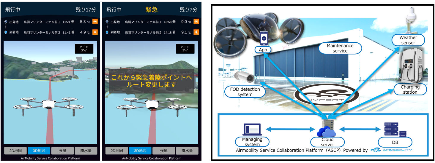
Overall of the demonstration
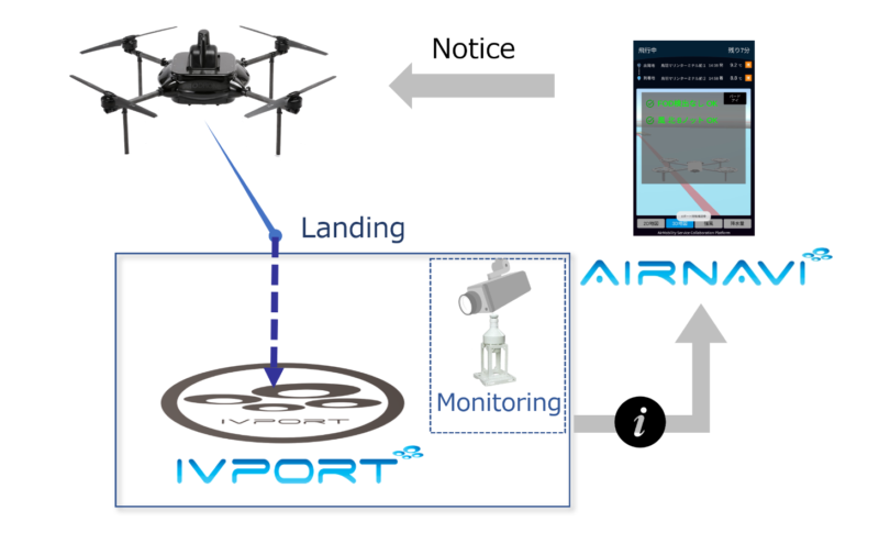
“AirNavi”, a key component of the AirMobility Service Collaboration Platform (ASCP) to navigate flight, was installed on the drone as an alternative to flying car for the demonstration.
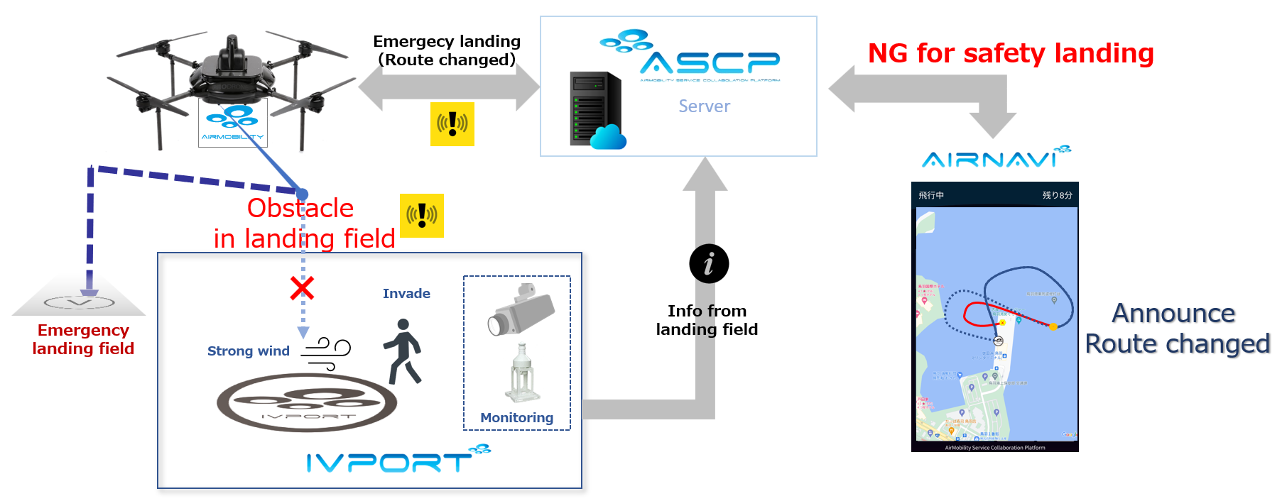
“AirNavi” supports the safe operation of flying vehicles by incorporating various conditions, including navigation functions such as route setting, real-time weather information, and information on takeoff and landing sites. In this demonstration, the takeoff/landing system called “IVport”, which is also a key component of the ASCP, was used to verify the two functions for normal landing operations and emergency landing operations.
Content of the demonstration
1)Demonstration to use the drone as an alternative to flying car and “AirNavi” to support safe flight.
2)Verified connected operation between ”AirNavi” and “IVport” in the case of a requirement for an emergency landing.
① General landing
The drone flied tracking location information from GPS, following to the route registered in AirNavi. As the drone approached the destination, AirNavi checked sensor information (presence of foreign objects, wind direction, and wind speed) as a pre-landing check with the IVport. After acquiring sensor information from the IVport, AirNavi determined whether the drone could land or not, and made a safe landing.
② Emergency landing
The drone flied tracking location information from GPS, following to the route registered in AirNavi. An obstacle was placed on the landing field during flight. As the drone approached the destination in the sky, AirNavi checked sensor information as a pre-landing check with IVport. After acquiring sensor information from the IVport, AirNavi determined it was not possible to land at the general landing field and redirected to emergency landing field as a new location for a safe landing.
■Demonstration date
February 6, 2023
■Location
Toba Marine Terminal
(1-2383-51, Toba, Toba City, Mie Prefecture)
■Flight route of the demonstration
Below was flight route around Toba Marine Terminal
Blue:General landing route
Yellow:Emergency landing route
 ※Flight route was shown in aerial photograph of Geospatial Information Authority of Japan
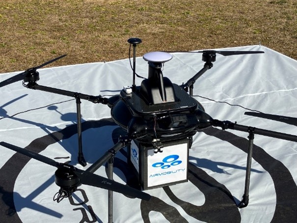
■Drone
ProDrone PD4B-M
Connected delivery box and installed tablet for application of AirNavi
■Companies cooperating in this demonstration project (in no particular order)
・Tokio Marine & Nichido Fire Insurance Co., Ltd.(provision of insurances)
・Prodrone Co., Ltd.(providing drone)
・Panasonic Corporation(providing person detection system)
・Weathernews Inc. (providing weather information)
・CHODAI CO.,LTD (providing take-off and landing sites)
・ZENRIN Co., LTD. (providing map data and 3D maps)
・Mie Prefecture, Toba City (provision of take-off and landing sites)
【For inquiries regarding this matter】
Contact person: Nagase and Hayashi
TEL:03-6273-1288
Email:info@airmobility.co.jp